Check the six course maps for this year

As the wet season is coming to a close in Yunnan, the traditional final check of this year’s race courses concluded last weekend. Compared to earlier announcements, only minor changes have been made to the original course maps, except the last one in Xishuangbanna. The final stage of this year’s Granfondo Yunnan event now measures 133km with about 2500 metres of elevation gain, promising more variety and scenery compared to last year’s edition.
As always, Yunnan is basically a mountain province so the event includes quite a bit of elevation gain and caters for people who can ride up and down a mountain or two. The five cities that we visit are the same as last year, i.e. Dehong/Mangshi, Baoshan/Tengchong, Lincang/Fengqing, Pu’Er/Simao and Xishuangbanna/Jinghong. The five stages in these cities also make up the general classification (GC) for Granfondo Yunnan. The Prologue Duo TT in Mangshi on the first day does not count towards the GC. Every day there is a long distance and a short distance category, as usual. Granfondo is a test of endurance and skill, so we always advise total beginners to start with the short distance first. The level of technicality on the long distance courses is significantly higher than on the short.
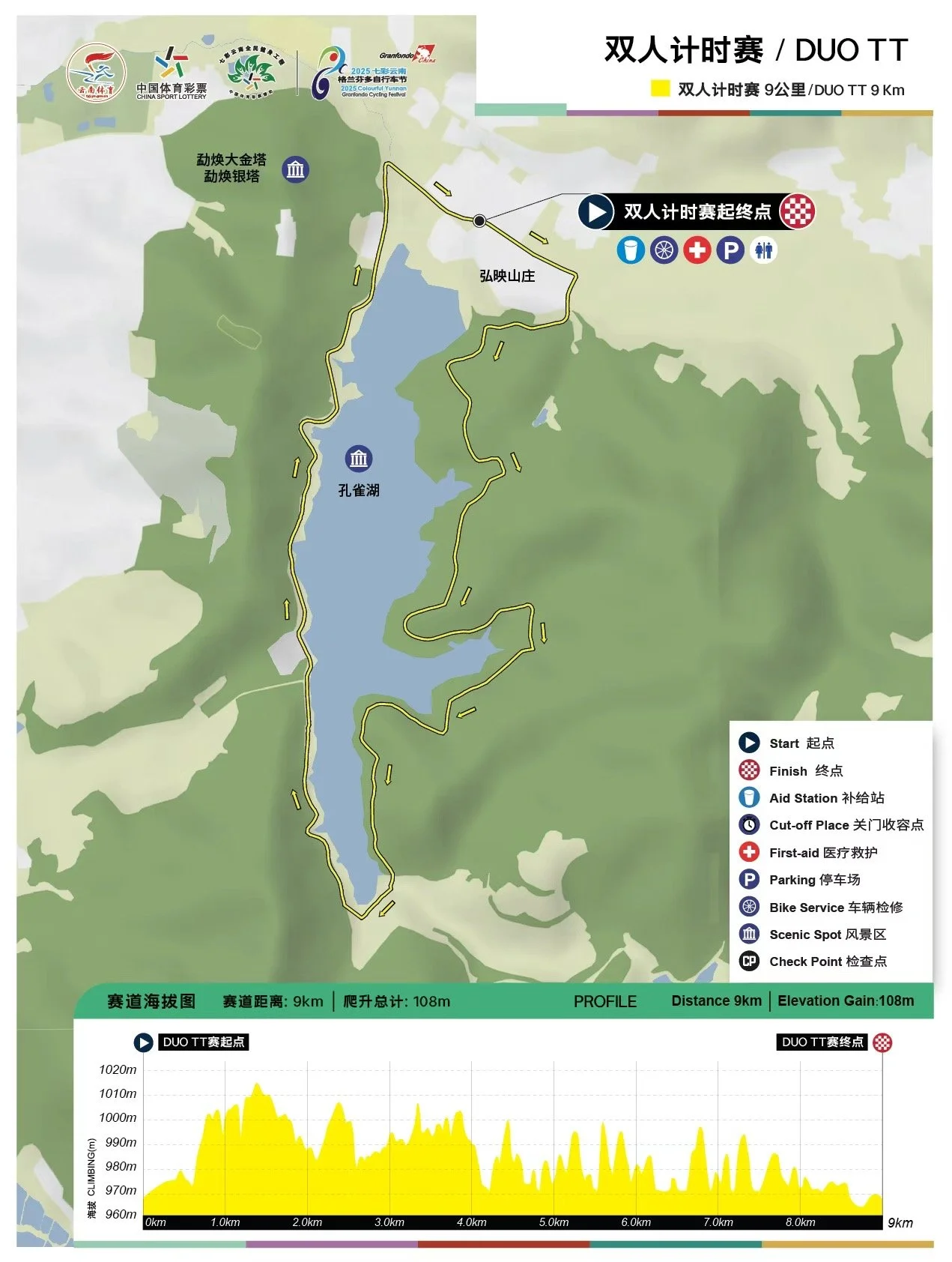
As you can see on the course maps below, the Mangshi Duo TT goes around the water reservoir next to the city centre for a loop of 9 km. In the interest of safety, and because of the many corners and quite a bit of up & down roads, we do not allow any TT bikes or TT handlebars - just your regular race bike. Pay attention also to the Duo TT rules, the two riders in a team must stay within two seconds of each other at the finish line. It’s not an individual TT, it’s a Duo TT.
Stage 1 of the regular Granfondo Yunnan programme is an adjusted version of last year’s with the climb of Jiandong Shan as key point for long distance participants. It’s a long climb, with a few steeper sections but in general for sure not the hardest either. A great warm-up for the rest of the week. That also implies for the descent, which has a few technical bits - enough to keep everyone’s guard up and to make everyone aware of what is coming later in the week. Besides the one mountain, the stage is basically ‘flat’. Total distance is 116km.
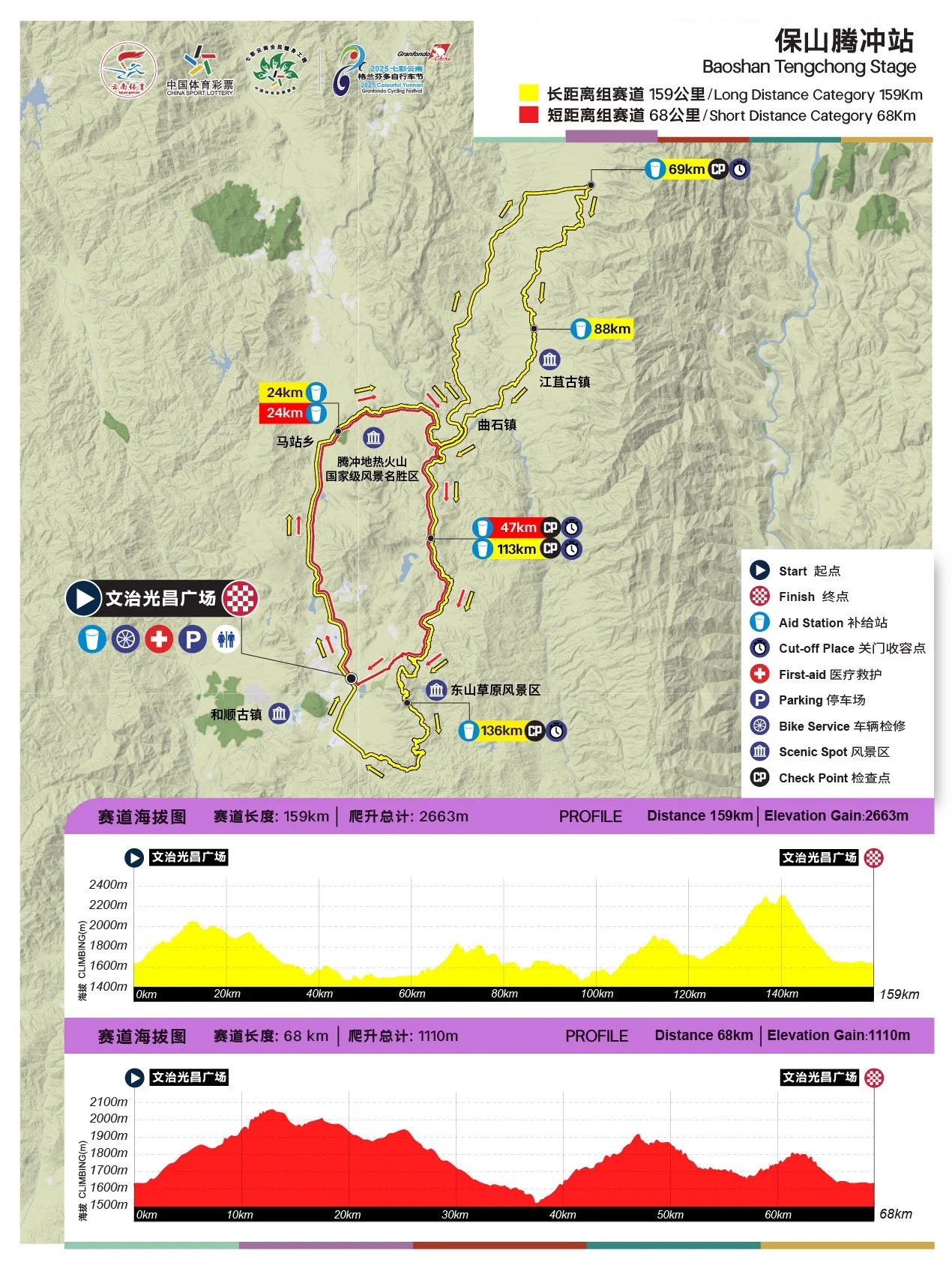
Every time we go to Tengchong we discover new places and roads great for cycling. So, also this year, the Tengchong stage is very different compared to previous years, while keeping a number of popular key spots. For many participants, Tengchong always turns out to be the toughest stage of the whole week due to its irregular nature, so be prepared mentally as well. This year, we go back to Huo Shan, the extinct volcano, and to the Wall of Tian Tai - the cobblestone climb in the spirit of the Tour of Flanders. We also return to Dong Shan at the end, but we will climb this beautiful mountain from the opposite direction. Total distance is 159km with about 2660 hm - yep, the real deal.
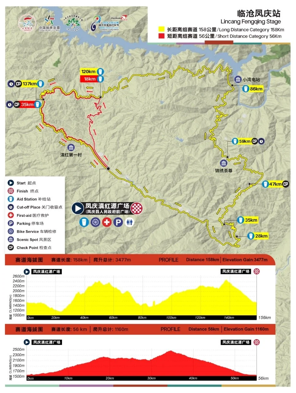
A rest day on Monday sets us up for the Queen’s Stage in Fengqing. A true mountain stage on exactly the same course as last year. While on paper this one certainly looks like the hardest stage of all - and for many it is also - the difference with Tengchong is that in Fengqing you can get into a nice comfortable rhythm during the race, which is a lot more difficult in Tengchong. The first mountain climb - named ‘Lucky Dragon Mountain - is narrow and requires focus, and so does the descent on the way to the big dam later on in the stage. When you reach the dam at KM 86, the hardest part is over. In total, the stage is 156 km long with about 3500 hm.
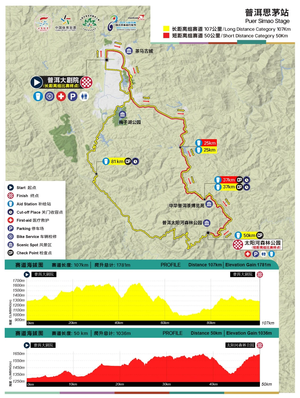
Another welcome rest day preceedes Stage 4 in Pu’Er. One of the easier stages , but a brilliant racing course for those who compete with a lot of bits in it where you can just blow up your legs. Arguably a stage where the punchier riders, rather than the mountain goats, will prevail. Note that the course is nearly the same as last year, but we go in the opposite direction. That means most climbing comes first. There’s a sting in the tail, however, in particular a short steep climb of about 1 km in length with 14km to go from the top.
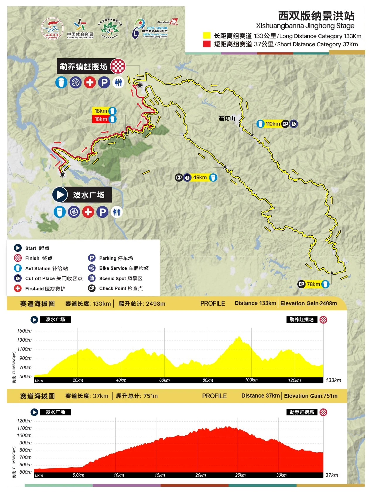
The last day in Xishuangbanna begins in the same way as last year, but after the split long distance and short distance, goes in the opposite direction from last year. Not all the way, we make a shortcut to Ya Nuo Team Mountain - a new climb in Granfondo Yunnan. Scenic and challenging. After a short descent - with two tricky switchbacks - you enter the main road that leads to the finish area, via a few bumps. The distance is 133km, almost 30km shorter than last year, but the views are more rewarding and the elevation gain…. remains the same: 2500 hm. Save some energy for this last stage!
GPX files will be circulated in the week before the start of the event. Note that last-minute adjustments to the courses are always possible, hence you should regard the GPX files as nothing else but a guideline (so you cannot get lost). We do not want to make these last-minute changes, but things can and do happen that make the occasional re-route necessary. The course markings on the road overrule any GPX file - as also stated in the competition regulations.