Updated stage course maps and profiles

Our race direction and technical team is currently double checking the current state of the roads along the courses of this year’s Granfondo Yunnan. At present, there’s little changes to what has been communicated before. The most significant amendments are as usual in Tengchong for the Along Gaoligong stage on Wednesday, 6 November. This is the area where the summer rains create most havoc.
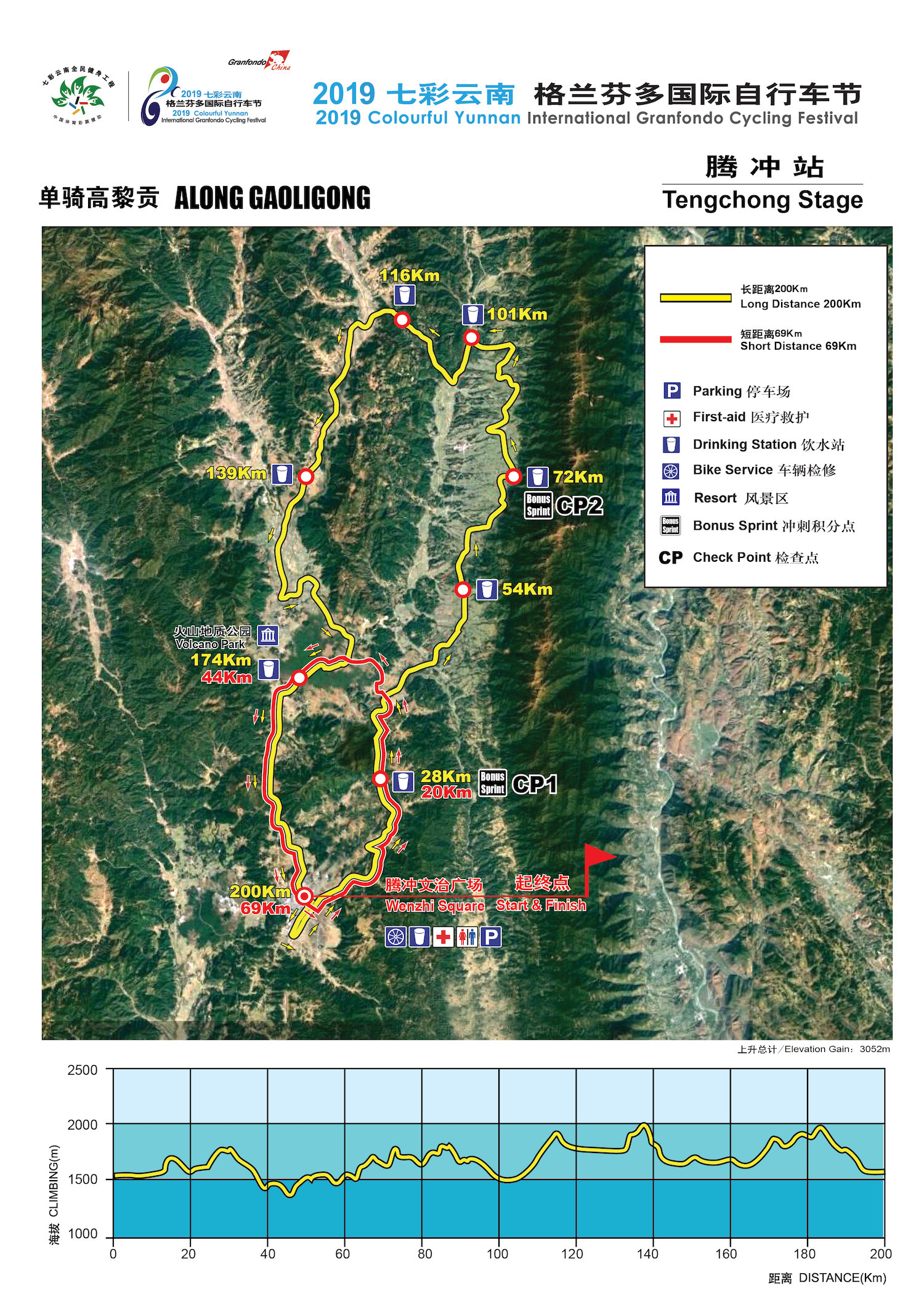
Stage 3 will now be effectively 200 km long and that’s a great thing and novelty for our event. Relax, the additional 15km compared to last year are flat :-). Along Gaoligong remains the most technical of all stages, though, and participants need to be well awake to negotiate the endless corners in this one. There’s probably more corners in this stage than in the entire rest of the week combined. However, as those who were here last year know, this stage is the real deal for a granfondo cyclist and when the weather plays along the views are amazing nearly all the way. Depending on which GPS system you use, the elevation gain seems to be between 2600 and 3000 hm. Note that there is a narrow passage of roughly 2,5 km through a village after only 13 km that cannot be avoided. As you will still be mostly grouped together, pay extra attention here! Short distance participants: this one is not so short with 69km and 1000 hm.
The Prologue TT in Mangshi and Stage 1 - The Border Ride to Ruili are both confirmed as they were planned. Once again, for those who came a year ago, this year the finish is further up at the Silver Pagoda - not the Golden Pagoda. After your time trial, you are free to descend and return to your hotel by yourself. Of course, do not even think of obstructing other riders who are still climbing up on their time trial. We have marshals everywhere to monitor. Those people who would like to go and take a look at the golden pagoda can do so. In fact, it is recommended.
The Border Ride from Mangshi to Ruili is straightforward. Short distance will finish at km 44, which is also the location of the first bonus time sprint for long distance riders. The bonus time are only calculated into the GC, not into the stage result. This year the first three men and first three women will score 12” - 9” - 6 “ bonus time. After you finish at the Myanmar border gate, you will have the opportunity to take a shower at the designated place. We advise you to do so, because at 14:30 you will hop on the bus for a 3 hour transfer to Yingjiang. We have postponed the start of stage 2 in Yingjiang - The River Ride - as much as possible to 9 am so you will still have enough rest. Please note that sometimes we need to play ball with local stakeholders - even if there’s some inconvenience involved for you as riders. Believe us, it’s also inconvenient for us and we have every incentive to keep that inconvenience as limited as possible.
The River Ride in Yingjiang is the brand new venue for this year’s edition. Most of the 118 km long course will indeed go along the big river, with a short excursion into a hilltop ethnic village between km 20 and 28. Be careful in the gradual descent here, this is a rather narrow concrete road. There is no point in racing downhill: you might hurt yourself if you do. When you hear whistles from the marshals it is for a reason. If you go smart, you will not have issues.
The short distance in Yingjiang is as flat as a race can be in these parts: 55 km and 200 hm. The long distance, however, will have a new iconic finish: the Col du Daonong, which leads to a festival square in a scenic lake area of Tongbiguan. Now the Col du Daonong is not to be underestimated and to be treated with utmost respect. Halfway up the 9km long ascent the gradient enters double digits. If you are comfortable riding uphill, you will be challenged but fine. If you are a sprint powerhouse or in any case not a mountain goat, you might wish to consider taking along a small enough gear. Something smaller than 39x27 to be on the safe side. Remember that Specialized will offer mechanical service at our event throughout the week. The finish of the stage is not on the summit, it is a 10 km rollercoaster further. The hornbill lampposts on both sides of Glory Lane will raise a smile on your face as you approach the line.
GPX files (FOR REFERENCE ONLY!!!)
During the races, you must follow the course signs and not the GPS. Last-minute changes to the race course can always occur and the course signs always have priority over the GPS files.